Tuesday, May 7, 2024
Home Blog Page 25

Montenegro Physical Map

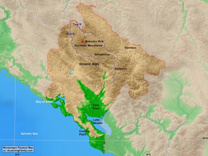
Montenegro physical map
A physical map of Montenegro (Creative Commons: A Learning Family).

The Montenegro physical map is provided. The physical map includes a list of major landforms and bodies of water of Montenegro.

A student may use the blank Montenegro outline map to practice locating these physical features.

Features of the Montenegro Physical Map

Bodies of Water

  • Adriatic Sea
  • Bay of Kotor

Major Landforms

  • Bjelasica Mountains
  • Bobotov Kuk
  • Coastal Plain
  • Dinaric Alps
  • Durmitor Mountains
  • Lake Skadar
  • Piva River
  • Sandzac Mountains
  • Sinjajevina Mountains
  • Tara River
  • Zeta Plain

Bibliography

Bulgaria Outline Map

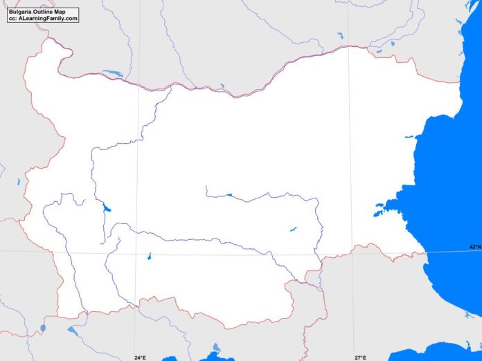
Bulgaria outline map
A blank outline map of Bulgaria (Creative Commons: A Learning Family).

The Bulgaria outline map is provided. The outline map includes a list of neighboring countries, major cities, major landforms and bodies of water of Bulgaria.

A student may use the blank map to practice locating these political and physical features. Click on the map for a full-sized image of the map.

Features of the Bulgaria Outline Map

Neighboring Countries

  • Greece
  • Macedonia
  • Romania
  • Serbia
  • Turkey

Major Cities

  • Sofia (capital)
  • Asenovgrad
  • Blagoevgrad
  • Burgas
  • Dobric
  • Gabrovo
  • Haskovo
  • Jambol
  • Kazaniak
  • Pazardzik
  • Pernik
  • Pleven
  • Plovdiv
  • Ruse
  • Silven
  • Stara Zagora
  • Sumen
  • Verna

Bodies of Water

  • Black Sea

Major Landforms

  • Balkan Mountains
  • Bosna Mountains
  • Danube River
  • Gora Mountains
  • Iskur River
  • Lisa Mountains
  • Ludogorie Mountains
  • Maritsa Basin
  • Maritsa River
  • Osogovski Mountains
  • Pirin Mountains
  • Rhodope Mountains
  • Rila Mountains
  • Sakar Mountains
  • Sredna Mountains
  • Struma River
  • Tundzha River
  • Vitosha Mountains

Bibliography

  • Bulgaria Political Map
  • Bulgaria Physical Map
  • Bulgaria

Bulgaria Political Map

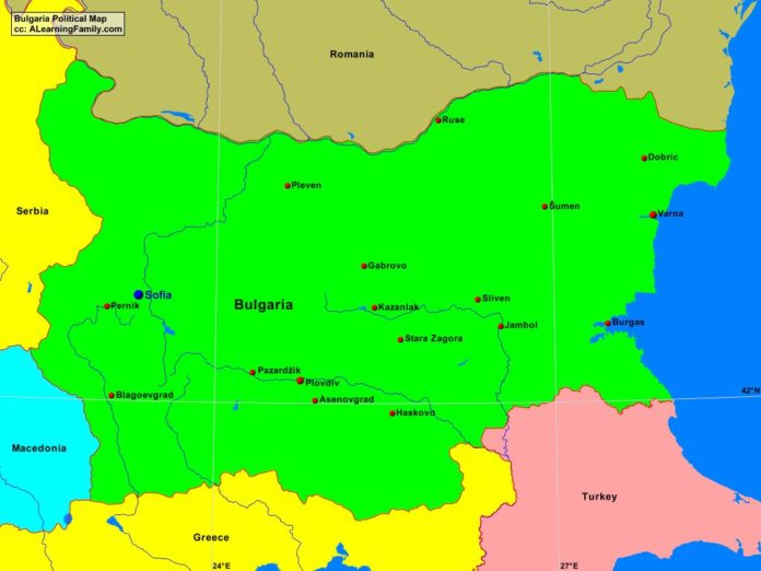
Bulgaria political map
A political map of Bulgaria (Creative Commons: A Learning Family).

The Bulgaria political map is provided. The political map includes a list of neighboring countries and major cities of Bulgaria.

A student may use the blank Bulgaria outline map to practice locating these political features.

Features of the Bulgaria Political Map

Neighboring Countries

  • Greece
  • Macedonia
  • Romania
  • Serbia
  • Turkey

Major Cities

  • Sofia (capital)
  • Asenovgrad
  • Blagoevgrad
  • Burgas
  • Dobric
  • Gabrovo
  • Haskovo
  • Jambol
  • Kazaniak
  • Pazardzik
  • Pernik
  • Pleven
  • Plovdiv
  • Ruse
  • Silven
  • Stara Zagora
  • Sumen
  • Verna

Bibliography

Bulgaria Physical Map

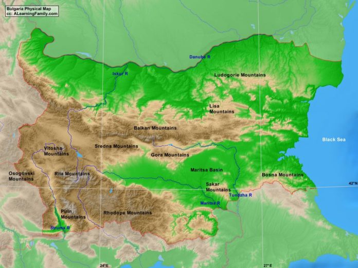
Bulgaria physical map
A physical map of Bulgaria (Creative Commons: A Learning Family).

The Bulgaria physical map is provided. The physical map includes a list of major landforms and bodies of water of Bulgaria.

A student may use the blank Bulgaria outline map to practice locating these physical features.

Features of the Bulgaria Physical Map

Bodies of Water

  • Black Sea

Major Landforms

  • Balkan Mountains
  • Bosna Mountains
  • Danube River
  • Gora Mountains
  • Iskur River
  • Lisa Mountains
  • Ludogorie Mountains
  • Maritsa Basin
  • Maritsa River
  • Osogovski Mountains
  • Pirin Mountains
  • Rhodope Mountains
  • Rila Mountains
  • Sakar Mountains
  • Sredna Mountains
  • Struma River
  • Tundzha River
  • Vitosha Mountains

Bibliography

Portugal Outline Map

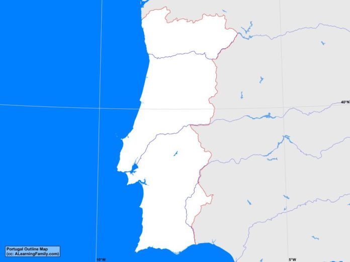
Portugal outline map
A blank outline map of Portugal (Creative Commons: A Learning Family).

The Portugal outline map is provided. The outline map includes a list of neighboring countries, major cities, major landforms and bodies of water of Portugal.

A student may use the blank map to practice locating these political and physical features.

Click on the map for a full-sized image of the country.

Features of the Portugal Outline Map

Neighboring Countries

  • Spain

Major Cities

  • Lisbon (capital)
  • Abrantes
  • Aguaiva-Cacem
  • Agueda
  • Aveiro
  • Beja
  • Braga
  • Braganca
  • Caldas da Rainha
  • Carregado
  • Castelo Branco
  • Coimbra
  • Corroios
  • Covilha
  • Custoias
  • Esmoriz
  • Evora
  • Faro
  • Grandola
  • Guarda
  • Lagos
  • Leiria
  • Mirandela
  • Porto

Bodies of Water

  • Atlantic Ocean
  • Gulf of Cadiz

Major Landforms

  • Alentejo
  • Algarve
  • Cantabrian Mountains
  • Douro River
  • Northern Meseta
  • Serra de Caldeirao
  • Serra de Estrella
  • Serra de Mogadouro
  • Serra de Monchique
  • Serra de Ossa
  • Serra do Aire
  • Sierra de Larouco
  • Southern Meseta
  • Tagus River
  • Torre

Bibliography

Portugal Political Map

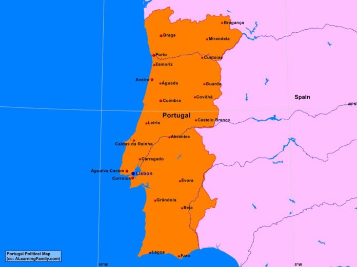
Portugal politicall map
A political map of Portugal (Creative Commons: A Learning Family).

The Portugal political map is provided. The political map includes a list of neighboring countries and major cities of Portugal.

A student may use the blank Portugal outline map to practice locating these political features.

Features of the Portugal Political Map

Neighboring Countries

  • Spain

Major Cities

  • Lisbon (capital)
  • Abrantes
  • Aguaiva-Cacem
  • Agueda
  • Aveiro
  • Beja
  • Braga
  • Braganca
  • Caldas da Rainha
  • Carregado
  • Castelo Branco
  • Coimbra
  • Corroios
  • Covilha
  • Custoias
  • Esmoriz
  • Evora
  • Faro
  • Grandola
  • Guarda
  • Lagos
  • Leiria
  • Mirandela
  • Porto

Bibliography

Portugal Physical Map

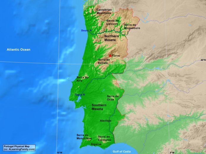
Portugal physical map
A physical map of Portugal (Creative Commons: A Learning Family).

The Portugal physical map is provided. The physical map includes a list of major landforms and bodies of water of Portugal.

A student may use the blank Portugal outline map to practice locating these physical features.

Features of the Portugal Physical Map

Bodies of Water

  • Atlantic Ocean
  • Gulf of Cadiz

Major Landforms

  • Alentejo
  • Algarve
  • Cantabrian Mountains
  • Douro River
  • Northern Meseta
  • Serra de Caldeirao
  • Serra de Estrella
  • Serra de Mogadouro
  • Serra de Monchique
  • Serra de Ossa
  • Serra do Aire
  • Sierra de Larouco
  • Southern Meseta
  • Tagus River
  • Torre

Bibliography

Czech Republic Outline Map

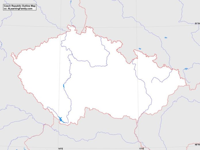
Czech Republic outline map
A blank outline map of the Czech Republic (Creative Commons: A Learning Family).

The Czech Republic outline map is provided. The outline map includes a list of neighboring countries, major cities, major landforms and bodies of water of Czech Republic.

A student may use the blank map to practice locating these political and physical features. Click on the map for a full-sized image of the map.

Features of the Czech Republic Outline Map

Neighboring Countries

  • Austria
  • Germany
  • Poland
  • Slovakia

Major Cities

  • Prague (capital)
  • Brno
  • Ceske Budejovice
  • Chomutov
  • Decin
  • Frydek-Mistek
  • Havirov
  • Hradec Kralove
  • Jihlava
  • Karlovy Vary
  • Karvina
  • Kladno
  • Liberec
  • Most
  • Olomouc
  • Opava
  • Ostrava
  • Pardubice
  • Pizen
  • Teplice
  • Usti
  • Zlin

Major Landforms

  • Biele-Karpaty Mountains
  • Bohemian Forest
  • Bohemian-Moravian Highlands
  • Elbe River
  • Javorniky Mountains
  • Morava River
  • Oder River
  • Ore Mountains
  • Orlice Mountains
  • Snezka
  • Sudetes Mountains
  • Sumava Mountains
  • Vitava River

Bibliography

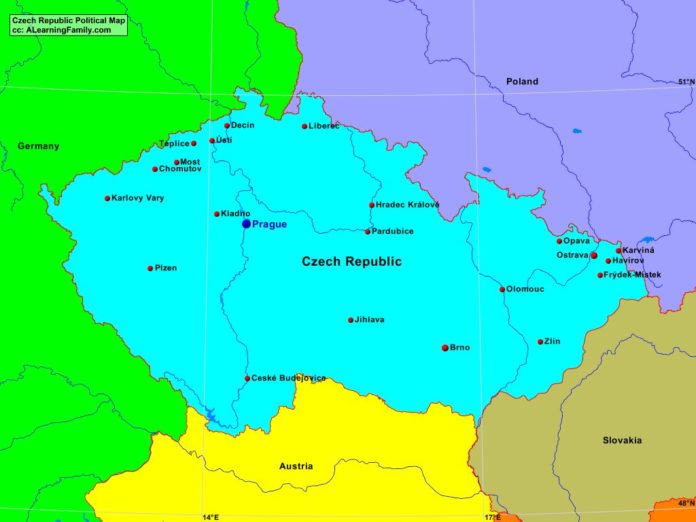
Czech Republic Political Map

Czech Republic political map
A political map of the Czech Republic (Creative Commons: A Learning Family).

The Czech Republic political map is provided. The political map includes a list of neighboring countries and major cities of the Czech Republic.

A student may use the blank Czech Republic outline map to practice locating these political features.

Features of the Czech Republic Political Map

Neighboring Countries

  • Austria
  • Germany
  • Poland
  • Slovakia

Major Cities

  • Prague (capital)
  • Brno
  • Ceske Budejovice
  • Chomutov
  • Decin
  • Frydek-Mistek
  • Havirov
  • Hradec Kralove
  • Jihlava
  • Karlovy Vary
  • Karvina
  • Kladno
  • Liberec
  • Most
  • Olomouc
  • Opava
  • Ostrava
  • Pardubice
  • Pizen
  • Teplice
  • Usti
  • Zlin

Bibliography

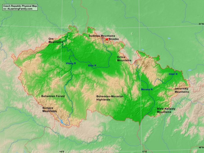
Czech Republic Physical Map

Czech Republic physical map
A physical map of the Czech Republic (Creative Commons: A Learning Family).

The Czech Republic physical map is provided. The physical map includes a list of major landforms and bodies of water of the Czech Republic.

A student may use the blank Czech Republic outline map to practice locating these physical features.

Features of the Czech Republic Physical Map

Major Landforms

  • Biele-Karpaty Mountains
  • Bohemian Forest
  • Bohemian-Moravian Highlands
  • Elbe River
  • Javorniky Mountains
  • Morava River
  • Oder River
  • Ore Mountains
  • Orlice Mountains
  • Snezka
  • Sudetes Mountains
  • Sumava Mountains
  • Vitava River

Bibliography

Featured Posts