Wednesday, May 8, 2024
Home Blog Page 27

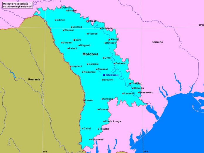
Moldova Political Map

Moldova political map
A political map of Moldova (Creative Commons: A Learning Family).

The Moldova political map is provided. The political map includes a list of neighboring countries and major cities of water of Moldova.

A student may use the blank Moldova outline map to practice locating these political features.

Features of the Moldova Political Map

Neighboring Countries

  • Romania
  • Ukraine

Major Cities

  • Chisinau (capital)
  • Balti
  • Briceni
  • Cahul
  • Calarasi
  • Camenca
  • Causeni
  • Cimislia
  • Cladir Lunga
  • Comrat
  • Dnestrovsc
  • Drochia
  • Dubasari
  • Edinet
  • Falesti
  • Floresti
  • Glodeni
  • Hincesti
  • Ialoveni
  • Leova
  • Nisporeni
  • Ocnita
  • Orhei
  • Ribnita
  • Riscani
  • Singerei
  • Slobozia
  • Soroca
  • Straseni
  • Taraclia
  • Tiraspol
  • Ungheni
  • Vulcanesti

Bibliography

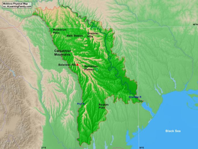
Moldova Physical Map

Moldova physical map
A physical map of Moldova (Creative Commons: A Learning Family).

The Moldova physical map is provided. The physical map includes a list of major landforms and bodies of water of Moldova.

A student may use the blank Moldova outline map to practice locating these physical features.

Features of the Moldova Physical Map

Bodies of Water

  • Black Sea

Major Landforms

  • Balanest Hill
  • Balti Steppe
  • Bugeac Plain
  • Carpathian Mountains
  • Dneister Hills
  • Dneister River
  • Moldavian Plain
  • Moldavian Plateau
  • Prut River

Bibliography

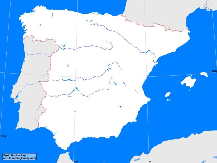
Spain Outline Map

Spain outline map
A blank outline map of Spain (Creative Commons: A Learning Family).

The Spain outline map is provided. The outline map includes a list of neighboring countries, major cities, major landforms and bodies of water of Spain.

A student may use the blank map to practice locating these political and physical features.

Features of the Spain Outline Map

Neighboring Countries

  • Algeria
  • Andorra
  • France
  • Morocco
  • Portugal

Major Cities

  • Madrid (capital)
  • A Coruna
  • Alacant
  • Alcala de Henares
  • Algeciras
  • Almeria
  • Badajoz
  • Barcelona
  • Bilbao
  • Burgos
  • Cadiz
  • Cartagena
  • Castello
  • Cordoba
  • Denostia
  • Gijon
  • Granada
  • Huelva
  • Jaen
  • Jerez
  • Leon
  • Lleida
  • Logrono
  • Malaga
  • Marbella
  • Mataro
  • Murcia
  • Oviedo
  • Ourense
  • Palma
  • Pamplona
  • Salamanca
  • Santander
  • Sevilla
  • Valencia
  • Valladolid
  • Vigo
  • Vitoria
  • Zaragoza

Bodies of Water

  • Balearic Sea
  • Bay of Biscay
  • Gulf of Cadiz
  • Mediterranean Sea
  • Strait of Gibraltar

Major Landforms

  • Baetic Depression
  • Baetic Mountains
  • Balearic Islands
  • Basque Mountains
  • Cantabrian Mountains
  • Catalan Coastal Range
  • Central System
  • Douro River
  • Ebro River
  • Galician Massif
  • Guadiana River
  • Iberian System
  • Meseta Norte
  • Meseta Sur
  • Mulhacen
  • Pyrennes Mountains
  • Sierra Morena
  • Tagus River
  • Valle Ibro

Bibliography

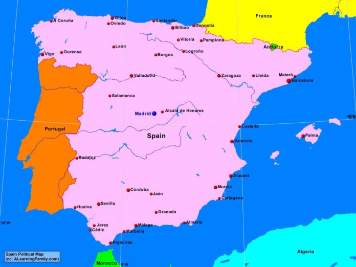
Spain Political Map

Spain political map
A political map of Spain (Creative Commons: A Learning Family).

The Spain political map is provided. The political map includes a list of neighboring countries and major cities of Spain.

A student may use the blank Spain outline map to practice locating these political features.

Features of the Spain Political Map

Neighboring Countries

  • Algeria
  • Andorra
  • France
  • Morocco
  • Portugal

Major Cities

  • Madrid (capital)
  • A Coruna
  • Alacant
  • Alcala de Henares
  • Algeciras
  • Almeria
  • Badajoz
  • Barcelona
  • Bilbao
  • Burgos
  • Cadiz
  • Cartagena
  • Castello
  • Cordoba
  • Denostia
  • Gijon
  • Granada
  • Huelva
  • Jaen
  • Jerez
  • Leon
  • Lleida
  • Logrono
  • Malaga
  • Marbella
  • Mataro
  • Murcia
  • Oviedo
  • Ourense
  • Palma
  • Pamplona
  • Salamanca
  • Santander
  • Sevilla
  • Valencia
  • Valladolid
  • Vigo
  • Vitoria
  • Zaragoza

Bibliography

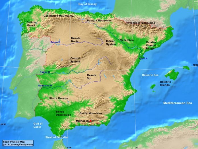
Spain Physical Map

Spain physical map
A physical map of Spain (Creative Commons: A Learning Family).

The Spain physical map is provided. The outline map includes a list of major landforms and bodies of water of Spain.

A student may use the blank Spain outline map to practice locating these physical features.

Features of the Spain Physical Map

Bodies of Water

  • Balearic Sea
  • Bay of Biscay
  • Gulf of Cadiz
  • Mediterranean Sea
  • Strait of Gibraltar

Major Landforms

  • Baetic Depression
  • Baetic Mountains
  • Balearic Islands
  • Basque Mountains
  • Cantabrian Mountains
  • Catalan Coastal Range
  • Central System
  • Douro River
  • Ebro River
  • Galician Massif
  • Guadiana River
  • Iberian System
  • Meseta Norte
  • Meseta Sur
  • Mulhacen
  • Pyrennes Mountains
  • Sierra Morena
  • Tagus River
  • Valle Ibro

Bibliography

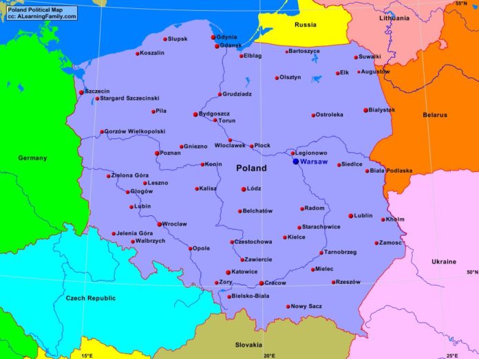
Poland Political Map

Poland political map
A political map of Poland (Creative Commons: A Learning Family).

The Poland political map is provided. The political map includes a list of neighboring countries and major cities of Poland.

A student may use the blank Poland outline map to practice locating these physical features.

Features of the Poland Political Map

Neighboring Countries

  • Belarus
  • Czech Republic
  • Germany
  • Lithuania
  • Russia
  • Slovakia
  • Ukraine

Major Cities

  • Warsaw (capital)
  • Augustow
  • Bartoszyce
  • Belchatow
  • Biala Podiaska
  • Bialystok
  • Bielsko-Biala
  • Bydgoszcz
  • Cracow
  • Czestochowa
  • Elblag
  • Elk
  • Gdansk
  • Gdynia
  • Glogow
  • Gniezno
  • Gorzow Wielkopolski
  • Grudziadz
  • Jelenia Gora
  • Kalisz
  • Katowice
  • Kholm
  • Kielce
  • Konin
  • Koszalin
  • Legionowo
  • Leszno
  • Lodz
  • Lublin
  • Mielec
  • Nowy Sacz
  • Olsztyn
  • Opole
  • Ostroleka
  • Pila
  • Plock
  • Poznan
  • Radom
  • Rzeszow
  • Siedice
  • Slupsk
  • Starachowice
  • Stargard Szczecinski
  • Suwaiki
  • Szczecin
  • Tarnobrzeg
  • Torun
  • Walbrzych
  • Wroclaw
  • Wroclawek
  • Zamosc
  • Zawiercie
  • Zielona Gora
  • Zory

Bibliography

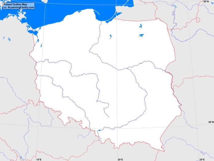
Poland Outline Map

Poland outline map
A blank outline map of Poland (Creative Commons: A Learning Family).

The Poland outline map is provided. The outline map includes a list of neighboring countries, major cities, major landforms and bodies of water of Poland.

A student may use the blank map to practice locating these political and physical features. Click on the map for a full-sized image of the map.

Features of the Poland Outline Map

Neighboring Countries

  • Belarus
  • Czech Republic
  • Germany
  • Lithuania
  • Russia
  • Slovakia
  • Ukraine

Major Cities

  • Warsaw (capital)
  • Augustow
  • Bartoszyce
  • Belchatow
  • Biala Podiaska
  • Bialystok
  • Bielsko-Biala
  • Bydgoszcz
  • Cracow
  • Czestochowa
  • Elblag
  • Elk
  • Gdansk
  • Gdynia
  • Glogow
  • Gniezno
  • Gorzow Wielkopolski
  • Grudziadz
  • Jelenia Gora
  • Kalisz
  • Katowice
  • Kholm
  • Kielce
  • Konin
  • Koszalin
  • Legionowo
  • Leszno
  • Lodz
  • Lublin
  • Mielec
  • Nowy Sacz
  • Olsztyn
  • Opole
  • Ostroleka
  • Pila
  • Plock
  • Poznan
  • Radom
  • Rzeszow
  • Siedice
  • Slupsk
  • Starachowice
  • Stargard Szczecinski
  • Suwaiki
  • Szczecin
  • Tarnobrzeg
  • Torun
  • Walbrzych
  • Wroclaw
  • Wroclawek
  • Zamosc
  • Zawiercie
  • Zielona Gora
  • Zory

Bodies of Water

  • Baltic Sea
  • Gulf of Gdansk
  • Pomeranian Bay

Major Landforms

  • Bug River
  • Carpathian Mountains
  • Central Lowlands
  • Masurian Lakeland
  • Oder River
  • Polish Uplands
  • Pomeranian Lakeland
  • Sandomierz Basin
  • Snezka
  • Sudetic Mountains
  • Vistula River
  • Warta River

Bibliography

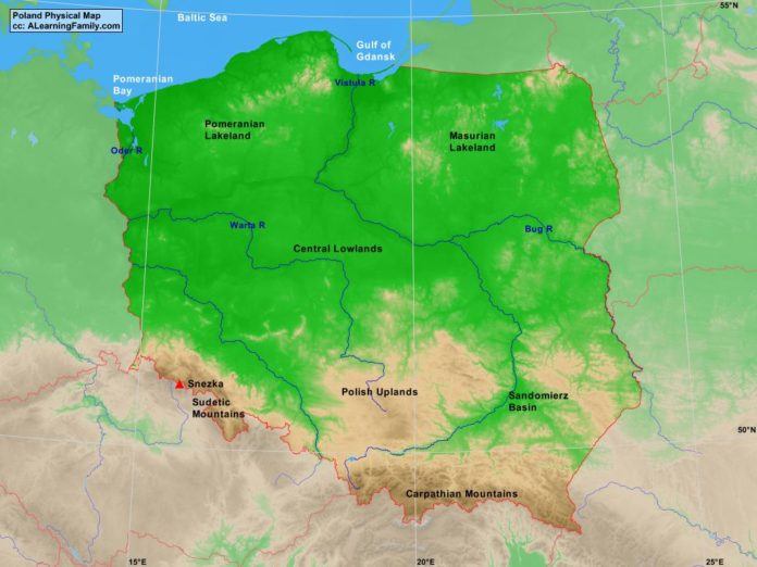
Poland Physical Map

Poland physical map
A physical map of Poland (Creative Commons: A Learning Family).

The Poland physical map is provided. The physical map includes a list of major landforms and bodies of water of Poland.

A student may use the blank Poland outline map to practice locating these physical features.

Features of the Poland Physical Map

Bodies of Water

  • Baltic Sea
  • Gulf of Gdansk
  • Pomeranian Bay

Major Landforms

  • Bug River
  • Carpathian Mountains
  • Central Lowlands
  • Masurian Lakeland
  • Oder River
  • Polish Uplands
  • Pomeranian Lakeland
  • Sandomierz Basin
  • Snezka
  • Sudetic Mountains
  • Vistula River
  • Warta River

Bibliography

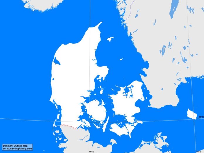
Denmark: Outline Map

Denmark outline map
A blank outline map of Denmark (Creative Commons: A Learning Family).

The Denmark outline map is provided. The outline map includes a list of neighboring countries, major cities, major landforms, and bodies of water of Denmark.

A student may use the blank map to practice locating these political and physical features.

Features of the Denmark Outline Map

Neighboring Countries

  • Germany
  • Norway
  • Sweden

Major Cities

  • Copenhagen (capital)
  • Aabenraa
  • Aalborg
  • Arhus
  • Birkered
  • Brondersiev
  • Esbjerg
  • Frederiksvark
  • Frederikshavn
  • Frederikssund
  • Greve Strand
  • Grenaa
  • Haderslev
  • Haslev
  • Herning
  • Hillerod
  • Hjerring
  • Hobro
  • Holstebro
  • Horsens
  • Koge
  • Korsor
  • Lemvig
  • Nakskov
  • Nastved
  • Nykobing
  • Odder
  • Odense
  • Randers
  • Ronne
  • Senderborg
  • Silkeborg
  • Skanderborg
  • Skive
  • Slagelse
  • Svendborg
  • Thisted
  • Varde
  • Vejle
  • Viborg

Bodies of Water

  • Arhus Bay
  • Baltic Sea
  • Fakse Bay
  • Jammer Bay
  • Kage Bay
  • Kattegat Bay
  • Kiel Bay
  • North Sea
  • Skaggerak Strait

Major Landforms

  • Als
  • Bornholm
  • Falster
  • Funen
  • Gudena River
  • Jutland Peninsula
  • Langeland
  • Lolland
  • Mollehoj
  • Mon
  • Samso
  • Skern River
  • Stora River
  • Varde River
  • Zealand

Bibliography

  • Denmark Political Map
  • Denmark Physical Map
  • Denmark

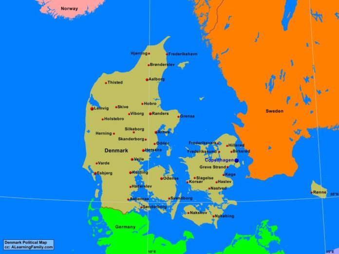
Denmark Political Map

Denmark political map
A political map of Denmark (Creative Commons: A Learning Family).

The Denmark political map is provided. The political map includes a list of neighboring countries and major cities of Denmark.

A student may use the blank Denmark outline map to practice locating these political features.

Features of the Denmark Political Map

Neighboring Countries

  • Germany
  • Norway
  • Sweden

Major Cities

  • Copenhagen (capital)
  • Aabenraa
  • Aalborg
  • Arhus
  • Birkered
  • Brondersiev
  • Esbjerg
  • Frederiksvark
  • Frederikshavn
  • Frederikssund
  • Greve Strand
  • Grenaa
  • Haderslev
  • Haslev
  • Herning
  • Hillerod
  • Hjerring
  • Hobro
  • Holstebro
  • Horsens
  • Koge
  • Korsor
  • Lemvig
  • Nakskov
  • Nastved
  • Nykobing
  • Odder
  • Odense
  • Randers
  • Ronne
  • Senderborg
  • Silkeborg
  • Skanderborg
  • Skive
  • Slagelse
  • Svendborg
  • Thisted
  • Varde
  • Vejle
  • Viborg

Bibliography

  • Denmark Political Map
  • Denmark Physical Map
  • Denmark

Featured Posts