Monday, May 20, 2024
Home Blog Page 28

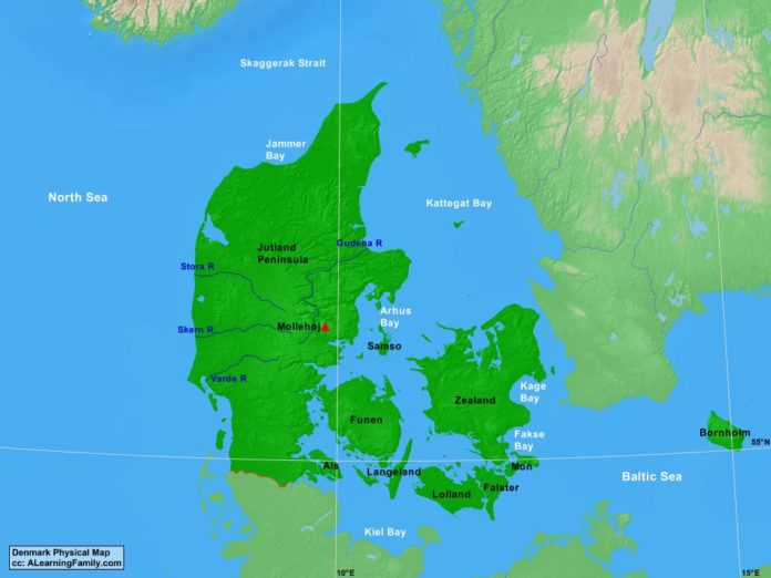
Denmark Physical Map

Denmark physical map
A physical map of Denmark (Creative Commons: A Learning Family).

The Denmark physical map is provided. The physical map includes a list of major landforms and bodies of water of Denmark.

A student may use the blank Denmark outline map to practice locating these physical features.

Features of the Denmark Physical Map

Bodies of Water

  • Arhus Bay
  • Baltic Sea
  • Fakse Bay
  • Jammer Bay
  • Kage Bay
  • Kattegat Bay
  • Kiel Bay
  • North Sea
  • Skaggerak Strait

Major Landforms

  • Als
  • Bornholm
  • Falster
  • Funen
  • Gudena River
  • Jutland Peninsula
  • Langeland
  • Lolland
  • Mollehoj
  • Mon
  • Samso
  • Skern River
  • Stora River
  • Varde River
  • Zealand

Bibliography

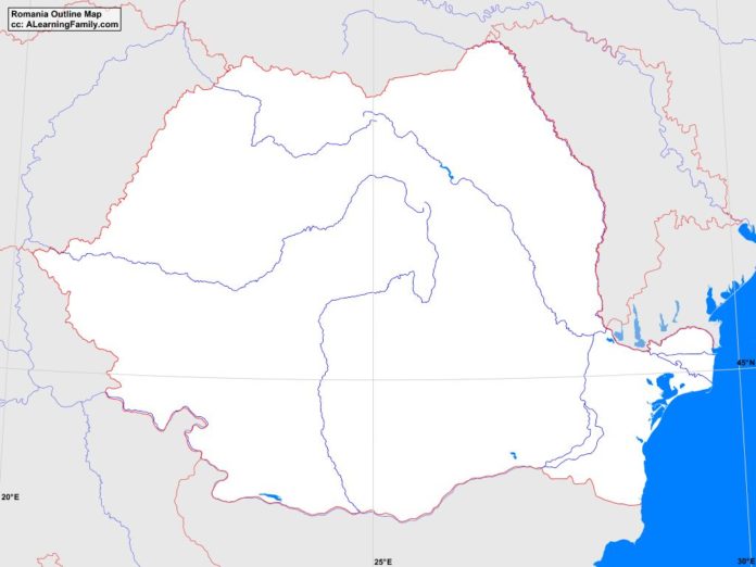
Romania Outline Map

Romania outline map
A blank outline map of Romania (Creative Commons: A Learning Family).

The Romania outline map is provided. The outline map includes a list of neighboring countries, major cities, major landforms and bodies of water of Romania.

A student may use the blank map to practice locating these political and physical features.

Features of the Romania Outline Map

Neighboring Countries

  • Bulgaria
  • Hungary
  • Moldova
  • Serbia
  • Ukraine

Major Cities

  • Bucharest (capital)
  • Alba Iulia
  • Arad
  • Baia Mare
  • Barlad
  • Bistrita
  • Botosani
  • Braila
  • Brasov
  • Buzau
  • Calarasi
  • Cluj-Napoca
  • Constanta
  • Craiova
  • Deva
  • Focsani
  • Galati
  • Giurgiu
  • Hunedoara
  • Iasi
  • Medias
  • Onesti
  • Oradea
  • Pitesti
  • Ploiesti
  • Resita
  • Roman
  • Satu Mare
  • Sibiu
  • Slatina
  • Slobozia
  • Suceava
  • Targu Jiu
  • Targu-Mures
  • Timisoara
  • Tulcea
  • Turda
  • Vaslui
  • Zalau

Bodies of Water

  • Black Sea

Major Landforms

  • Bihor Mountains
  • Danube River
  • Danubian Plain
  • Eastern Carpathians
  • Harghita Mountains
  • Moldoveanu
  • Moldovian Plateau
  • Mures River
  • Oas Mountains
  • Olt River
  • Prut River
  • Rodna Massif
  • Siret River
  • Somes River
  • Transylvanian Alps
  • Transylvanian Plateau
  • Western Carpathians

Bibliography

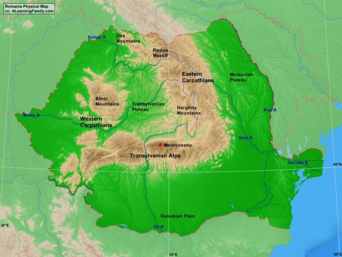
Romania Physical Map

Romania physical map
A physical map of Romania (Creative Commons: A Learning Family).

The Romania physical map is provided. The physical map includes a list of major landforms and bodies of water of Romania.

A student may use the blank Romania outline map to practice locating these physical features.

Features of the Romania Physical Map

Bodies of Water

  • Black Sea

Major Landforms

  • Bihor Mountains
  • Danube River
  • Danubian Plain
  • Eastern Carpathians
  • Harghita Mountains
  • Moldoveanu
  • Moldovian Plateau
  • Mures River
  • Oas Mountains
  • Olt River
  • Prut River
  • Rodna Massif
  • Siret River
  • Somes River
  • Transylvanian Alps
  • Transylvanian Plateau
  • Western Carpathians

Bibliography

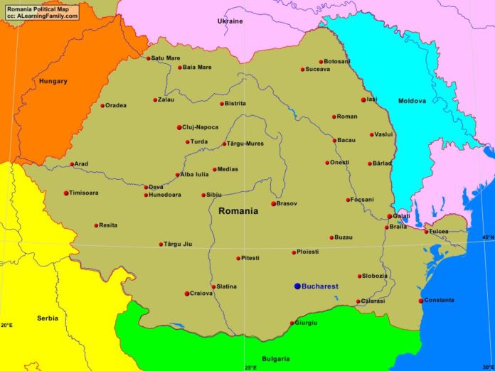
Romania Political Map

Romania political map
A political map of Romania (Creative Commons: A Learning Family).

The Romania political map is provided. The political map includes a list of neighboring countries and major cities of Romania.

A student may use the blank Romania outline map to practice locating these political features.

Features of the Romania Political Map

Neighboring Countries

  • Bulgaria
  • Hungary
  • Moldova
  • Serbia
  • Ukraine

Major Cities

  • Bucharest (capital)
  • Alba Iulia
  • Arad
  • Baia Mare
  • Barlad
  • Bistrita
  • Botosani
  • Braila
  • Brasov
  • Buzau
  • Calarasi
  • Cluj-Napoca
  • Constanta
  • Craiova
  • Deva
  • Focsani
  • Galati
  • Giurgiu
  • Hunedoara
  • Iasi
  • Medias
  • Onesti
  • Oradea
  • Pitesti
  • Ploiesti
  • Resita
  • Roman
  • Satu Mare
  • Sibiu
  • Slatina
  • Slobozia
  • Suceava
  • Targu Jiu
  • Targu-Mures
  • Timisoara
  • Tulcea
  • Turda
  • Vaslui
  • Zalau

Bibliography

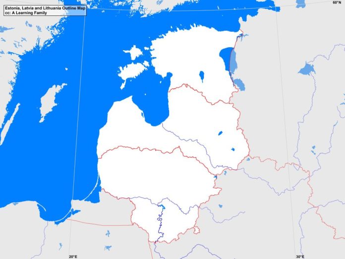
Estonia, Latvia and Lithuania Outline Map

Estonia Latvia and Lithuania outline map
A blank outline map of Estonia, Latvia and Lithuania (Creative Commons: A Learning Family).

The Estonia, Latvia and Lithuania outline map is provided. The outline map includes a list of neighboring countries, major cities, major landforms and bodies of water of Estonia, Latvia, and Lithuania.

A student may use the blank map to practice locating these political and physical features.

Features of the Estonia, Latvia, and Lithuania Outline Map

Neighboring Countries

  • Belarus
  • Finland
  • Poland
  • Russia
  • Sweden

Major Cities

  • Tallinn (capital)
  • Riga (capital)
  • Vilnius (capital)
  • Alystus
  • Daugavpils
  • Haapsalu
  • Jekabspils
  • Jelgava
  • Johvi
  • Jonava
  • Jurmala
  • Kaunas
  • Kedainiai
  • Klaipeda
  • Kohtla-Jarve
  • Kuressaare
  • Liepaja
  • Livani
  • Ludza
  • Marijampole
  • Mazeikiai
  • Narva
  • Ogre
  • Olaine
  • Palanga
  • Panevezys
  • Parnu
  • Radviliskis
  • Rakvere
  • Rezekne
  • Siaulial
  • Tartu
  • Utena
  • Valga
  • Valmiera
  • Ventaspils
  • Visaginas

Bodies of Water

  • Baltic Sea
  • Gulf of Finland
  • Gulf of Riga

Major Landforms

  • Aukstojas Hill
  • Baltic Highlands
  • Central Vidzeme Upland
  • Coastal Lowland
  • Daugava River
  • East Latvian Lowland
  • Eastern Kurzene Upland
  • Gaizinkalns
  • Haanja Upland
  • Hiiumaa
  • Lake Peipus
  • Middle Latvian Lowland
  • Middle Lithuanian Lowland
  • Nemunas River
  • Otepaa Upland
  • Pandivere Upland
  • Saaremaa
  • Suur Munamagi
  • Western Kurzene Upland
  • Zemaiciai Upland
  • Zemgale Plain

Bibliography

  • Estonia, Latvia and Lithuania Political Map
  • Estonia, Latvia and Lithuania Physical Map
  • Estonia

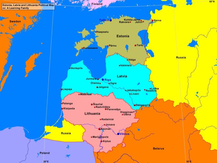
Estonia, Latvia and Lithuania Political Map

Estonia Latvia Lithuania political map
A political map of Estonia, Latvia and Lithuania (Creative Commons: A Learning Family).

The Estonia, Latvia and Lithuania political map is provided. The political map includes a list of neighboring countries and major cities of Estonia, Latvia, and Lithuania.

A student may use the blank Estonia, Latvia and Lithuania outline map to practice locating these political features.

Features of the Estonia, Latvia and Lithuania Political Map

Neighboring Countries

  • Belarus
  • Finland
  • Poland
  • Russia
  • Sweden

Major Cities

  • Tallinn (capital)
  • Riga (capital)
  • Vilnius (capital)
  • Alystus
  • Daugavpils
  • Haapsalu
  • Jekabspils
  • Jelgava
  • Johvi
  • Jonava
  • Jurmala
  • Kaunas
  • Kedainiai
  • Klaipeda
  • Kohtla-Jarve
  • Kuressaare
  • Liepaja
  • Livani
  • Ludza
  • Marijampole
  • Mazeikiai
  • Narva
  • Ogre
  • Olaine
  • Palanga
  • Panevezys
  • Parnu
  • Radviliskis
  • Rakvere
  • Rezekne
  • Siaulial
  • Tartu
  • Utena
  • Valga
  • Valmiera
  • Ventaspils
  • Visaginas

Bibliography

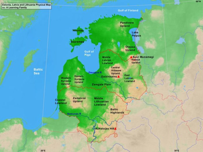
Estonia, Latvia and Lithuania Physical Map

Estonia Latvia and Lithuania physical map
A physical map of Estonia, Latvia and Lithuania (Creative Commons: A Learning Family).

The Estonia, Latvia and Lithuania physical map is provided. The physical map includes a list of major landforms and bodies of water of Estonia, Latvia, and Lithuania.

A student may use the blank Estonia, Latvia and Lithuania outline map to practice locating these physical features.

Features of the Estonia, Latvia, and Lithuania Physical Map

Bodies of Water

  • Baltic Sea
  • Gulf of Finland
  • Gulf of Riga

Major Landforms

  • Aukstojas Hill
  • Baltic Highlands
  • Central Vidzeme Upland
  • Coastal Lowland
  • Daugava River
  • East Latvian Lowland
  • Eastern Kurzene Upland
  • Gaizinkalns
  • Haanja Upland
  • Hiiumaa
  • Lake Peipus
  • Middle Latvian Lowland
  • Middle Lithuanian Lowland
  • Nemunas River
  • Otepaa Upland
  • Pandivere Upland
  • Saaremaa
  • Suur Munamagi
  • Western Kurzene Upland
  • Zemaiciai Upland
  • Zemgale Plain

Bibliography

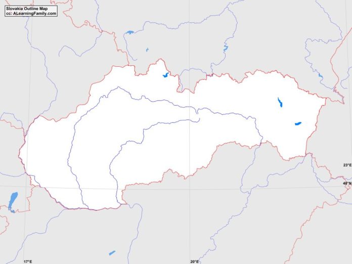
Slovakia Outline Map

Slovakia outline map
A blank outline map of Slovakia (Creative Commons: A Learning Family).

The Slovakia outline map is provided. The outline map includes a list of neighboring countries, major cities, major landforms and bodies of water of Slovakia.

A student may use the blank map to practice locating these political and physical features.

Features of the Slovakia Outline Map

Neighboring Countries

  • Austria
  • Czech Republic
  • Hungary
  • Poland
  • Ukraine

Major Cities

  • Bratislava (capital)
  • Banska Bystrica
  • Bardejov
  • Cadca
  • Dubnica
  • Humenne
  • Komarno
  • Kosice
  • Levice
  • Lucenec
  • Martin
  • Michalovce
  • Nitra
  • Nove Zamky
  • Piest’any
  • Poprad
  • Presov
  • Prievidza
  • Povazska Bystrica
  • Ruzomberok
  • Spisska Nova Ves
  • Topol’cany
  • Trencin
  • Trnava
  • Zilina

Major Landforms

  • Carpathian Mountains
  • Danube River
  • Danubian Hills
  • Danubian Lowlands
  • Eastern Slovak Hills
  • Eastern Slovak Lowlands
  • Gerlaschovsky stit
  • High Tatra Mountains
  • Hornad River
  • Hron River
  • Javorniky Mountains
  • Little Carpathians
  • Low Tatra Mountains
  • Morava River
  • Ore Mountains
  • Slovak Central Mountains
  • Vah River

Bibliography

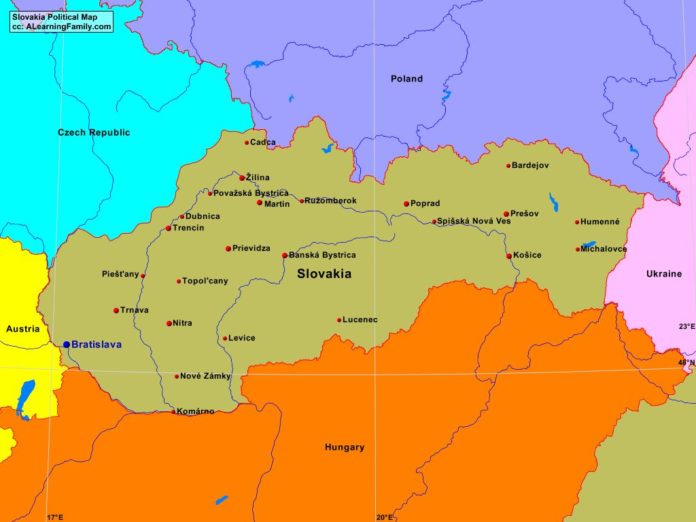
Slovakia Political Map

Slovakia political map
A political map of Slovakia (Creative Commons: A Learning Family).

The Slovakia political map is provided. The political map includes a list of neighboring countries and major cities of Slovakia.

A student may use the blank Slovakia outline map to practice locating these political features.

Features of the Slovakia Political Map

Neighboring Countries

  • Austria
  • Czech Republic
  • Hungary
  • Poland
  • Ukraine

Major Cities

  • Bratislava (capital)
  • Banska Bystrica
  • Bardejov
  • Cadca
  • Dubnica
  • Humenne
  • Komarno
  • Kosice
  • Levice
  • Lucenec
  • Martin
  • Michalovce
  • Nitra
  • Nove Zamky
  • Piest’any
  • Poprad
  • Presov
  • Prievidza
  • Povazska Bystrica
  • Ruzomberok
  • Spisska Nova Ves
  • Topol’cany
  • Trencin
  • Trnava
  • Zilina

Bibliography

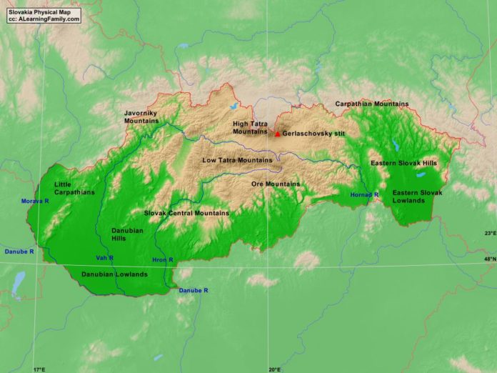
Slovakia Physical Map

Slovakia physical map
A physical map of Slovakia (Creative Commons: A Learning Family).

The Slovakia physical map is provided. The physical map includes a list of major landforms and bodies of water of Slovakia.

A student may use the blank Slovakia outline map to practice locating these physical features.

Features of the Slovakia Physical Map

Major Landforms

  • Carpathian Mountains
  • Danube River
  • Danubian Hills
  • Danubian Lowlands
  • Eastern Slovak Hills
  • Eastern Slovak Lowlands
  • Gerlaschovsky stit
  • High Tatra Mountains
  • Hornad River
  • Hron River
  • Javorniky Mountains
  • Little Carpathians
  • Low Tatra Mountains
  • Morava River
  • Ore Mountains
  • Slovak Central Mountains
  • Vah River

Bibliography

Featured Posts