Sunday, May 19, 2024
Home Blog Page 43

East Asia Physical Map

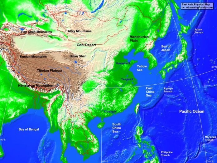
East Asia physical map
A physical map of East Asia (Creative Commons: A Learning Family).

The East Asia physical map is provided. The physical map includes a list of major landforms and bodies of water of East Asia.

A student may use the blank East Asia outline map to practice locating these physical features.

Features of the East Asia Physical Map

Bodies of Water

  • Bay of Bengal
  • East China Sea
  • Pacific Ocean
  • Sea of Japan
  • South China Sea
  • Yellow Sea

Major Landforms

  • Altay Mountains
  • Gobi Desert
  • Himalayan Mountains
  • Huang He River
  • Japan Trench
  • Kunlun Mountains
  • Manchurian Plain
  • Marianas Trench
  • Philippine Trench
  • Qilian Shan
  • Ryukyu Trench
  • Tibetan Plateau
  • Tian Shan Mountains
  • Xi Jiang River
  • Yangtze River

Bibliography

Oceania Outline Map

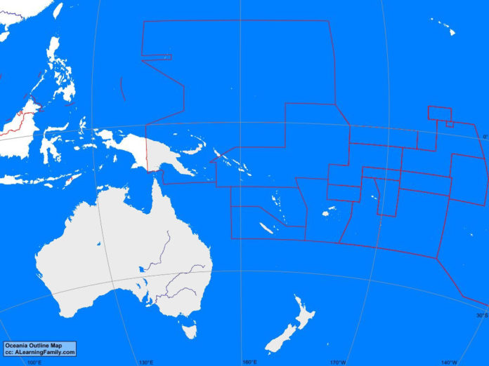
Oceania outline map
A blank outline map of Oceania (Creative Commons: A Learning Family).

The Oceania outline map is provided. The outline map includes a list of neighboring countries, major cities, major landforms and bodies of water of Oceania.

A student may use the blank map to practice locating these political and physical features.

Features of the Oceania Outline Map

Neighboring Countries

  • Brunei
  • East Timor
  • Indonesia
  • Malaysia
  • Philippines
  • Taiwan

Countries and Capitals

  • Australia (Canberra)
  • Fiji (Suva)
  • Kiribati (Bairiki)
  • Marshall Islands (Majuro)
  • Micronesia (Palikir)
  • Nauru (Yaren)
  • New Zealand (Wellington)
  • Papua New Guinea (Port Moresby)
  • Samoa (Apia)
  • Solomon Islands (Honiara)
  • Tonga (Nuku’Alofa)
  • Tuvalu (Valaku)
  • Vanuatu (Vila)

Bodies of Water

  • Arafura Sea
  • Coral Sea
  • Indian Ocean
  • Pacific Ocean
  • Philippine Sea
  • Tasman Sea
  • Timor Sea

Major Landforms

  • Bouganville Trench
  • Great Dividing Range
  • Great Sandy Desert
  • Kermadec Trench
  • Marianas Trench
  • Nullarbor Plain
  • Philippine Trench
  • Simpson Desert
  • Tonga Trench

Bibliography

Oceania Political Map

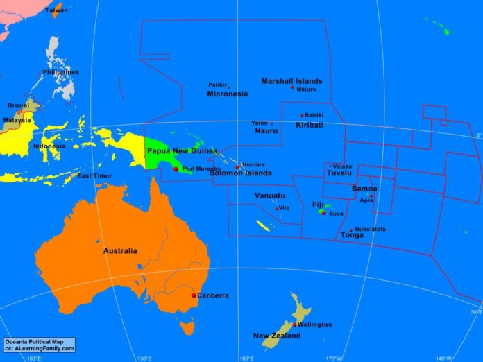
Oceania political map
A political map of Oceania (Creative Commons: A Learning Family).

The Oceania political map is provided. The political map includes a list of neighboring countries and major cities of Oceania.

A student may use the blank Oceania outline map to practice locating these political features.

Features of the Oceania Political Map

Neighboring Countries

  • Brunei
  • East Timor
  • Indonesia
  • Malaysia
  • Philippines
  • Taiwan

Countries and Capitals

  • Australia (Canberra)
  • Fiji (Suva)
  • Kiribati (Bairiki)
  • Marshall Islands (Majuro)
  • Micronesia (Palikir)
  • Nauru (Yaren)
  • New Zealand (Wellington)
  • Papua New Guinea (Port Moresby)
  • Samoa (Apia)
  • Solomon Islands (Honiara)
  • Tonga (Nuku’Alofa)
  • Tuvalu (Valaku)
  • Vanuatu (Vila)

Bibliography

Oceania Physical Map

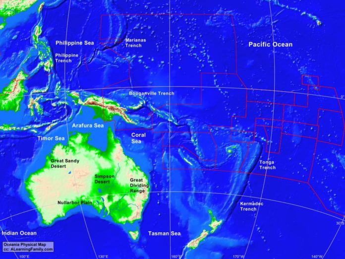
Oceania physical map
A physical map of Oceania (Creative Commons: A Learning Family).

The Oceania physical map is provided. The physical map includes a list of major landforms and bodies of water of Oceania.

A student may use the blank Oceania outline map to practice locating these physical features.

Features of the Oceania Physical Map

Bodies of Water

  • Arafura Sea
  • Coral Sea
  • Indian Ocean
  • Pacific Ocean
  • Philippine Sea
  • Tasman Sea
  • Timor Sea

Major Landforms

  • Bouganville Trench
  • Great Dividing Range
  • Great Sandy Desert
  • Kermadec Trench
  • Marianas Trench
  • Nullarbor Plain
  • Philippine Trench
  • Simpson Desert
  • Tonga Trench

Bibliography

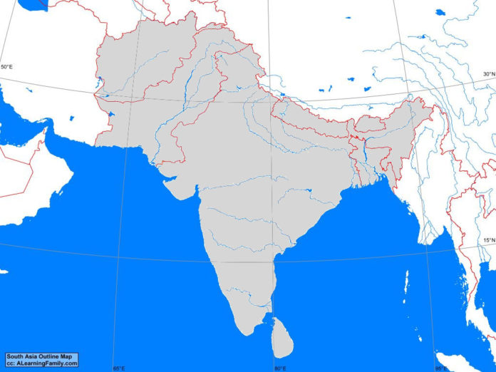
South Asia Outline Map

South Asia outline map
A blank outline map of South Asia (Creative Commons: A Learning Family).

The South Asia outline map is provided. The outline map includes a list of neighboring countries, major cities, major landforms and bodies of water of South Asia.

A student may use the blank map to practice locating these political and physical features.

Features of the South Asia Outline Map

Neighboring Countries

  • Burma
  • China
  • Iran

Countries and Capital Cities

  • Afghanistan (Kabul)
  • Bangladesh (Dhaka)
  • Bhutan (Thimphu)
  • India (New Delhi)
  • Nepal (Kathmandu)
  • Pakistan (Islamabad)
  • Sri Lanka (Sri Jayawardenepura)

Bodies of Water

  • Arabian Sea
  • Bay of Bengal

Major Landforms

  • Brahmaputra River
  • Deccan Plateau
  • Eastern Ghats
  • Ganges River
  • Himalaya Mountains
  • Hindu Kush Mountains
  • Indo-Gangetic Plain
  • Indus River
  • Karakorum Range
  • Makran Coast Range
  • Thar Desert
  • Western Ghats

Bibliography

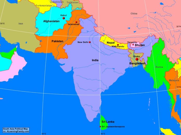
South Asia Political Map

South Asia political map
A political map of South Asia (Creative Commons: A Learning Family).

The South Asia political map is provided. The political map includes a list of neighboring countries and capital cities of South Asia.

A student may use the blank South Asia outline map to practice locating these political features.

Features of the South Asia Political Map

Neighboring Countries

  • Burma
  • China
  • Iran

Countries and Capital Cities

  • Afghanistan (Kabul)
  • Bangladesh (Dhaka)
  • Bhutan (Thimphu)
  • India (New Delhi)
  • Nepal (Kathmandu)
  • Pakistan (Islamabad)
  • Sri Lanka (Sri Jayawardenepura)

Bibliography

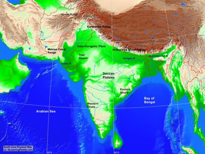
South Asia Physical Map

South Asia physical map
A physical map of South Asia (Creative Commons: A Learning Family).

The South Asia physical map is provided. The physical map includes a list of major landforms and bodies of water of South Asia.

A student may use the blank South Asia outline map to practice locating these physical features.

Features of the South Asia Physical Map

Bodies of Water

  • Arabian Sea
  • Bay of Bengal

Major Landforms

  • Brahmaputra River
  • Deccan Plateau
  • Eastern Ghats
  • Ganges River
  • Himalaya Mountains
  • Hindu Kush Mountains
  • Indo-Gangetic Plain
  • Indus River
  • Karakorum Range
  • Makran Coast Range
  • Thar Desert
  • Western Ghats

Bibliography

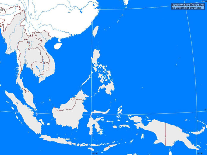
Southeast Asia Outline Map

Southeast Asia outline map
A blank outline map of Southeast Asia (Creative Commons: A Learning Family).

The Southeast Asia outline map is provided. The outline map includes a list of neighboring countries, capital cities, major landforms and bodies of water of Southeast Asia.

A student may use the blank map to practice locating these political and physical features.

Features of the Southeast Asia Outline Map

Neighboring Countries

  • Bangladesh
  • China
  • India
  • New Guinea

Countries and Capital Cities

  • Bandar Seri (Begawan)
  • Burma (Nyapyidaw)
  • Cambodia (Phnom Penh)
  • East Timor (Dili)
  • Indonesia (Jakarta)
  • Laos (Vientiane)
  • Malaysia (Kuala Lumpur)
  • Philippines (Manila)
  • Singapore (Singapore)
  • Thailand (Bangkok)
  • Vietnam (Ha Noi)

Bodies of Water

  • Andaman Sea
  • Banda Sea
  • Celebes Sea
  • East China Sea
  • Flores Sea
  • Gulf of Thailand
  • Indian Ocean
  • Java Sea
  • Pacific Ocean
  • Philippine Sea
  • South China Sea
  • Sulu Sea
  • Timor Sea

Major Landforms

  • Andaman Islands
  • Borneo
  • Chao Phraya River
  • Hainan
  • Irrawaddy River
  • Java
  • Java Trench
  • Luzon
  • Marianas Trench
  • Mekong River
  • Mindanao
  • New Guinea
  • Philippine Trench
  • Red River
  • Spratly Islands
  • Sulawesi
  • Sumatra
  • Visayas

Bibliography

Southeast Asia Political Map

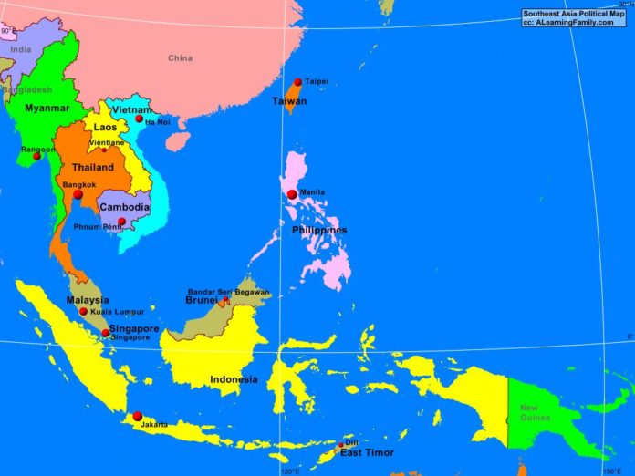
Southeast Asia political map
A political map of Southeast Asia (Creative Commons: A Learning Family).

The Southeast Asia political map is provided. The political map includes a list of neighboring countries and capital cities of Southeast Asia.

A student may use the blank Southeast Asia outline map to practice locating these political features.

Features of the Southeast Asia Political Map

Neighboring Countries

  • Bangladesh
  • China
  • India
  • New Guinea

Countries and Capital Cities

  • Bandar Seri (Begawan)
  • Burma (Nyapyidaw)
  • Cambodia (Phnom Penh)
  • East Timor (Dili)
  • Indonesia (Jakarta)
  • Laos (Vientiane)
  • Malaysia (Kuala Lumpur)
  • Philippines (Manila)
  • Singapore (Singapore)
  • Thailand (Bangkok)
  • Vietnam (Ha Noi)

Bibliography

Southeast Asia Physical Map

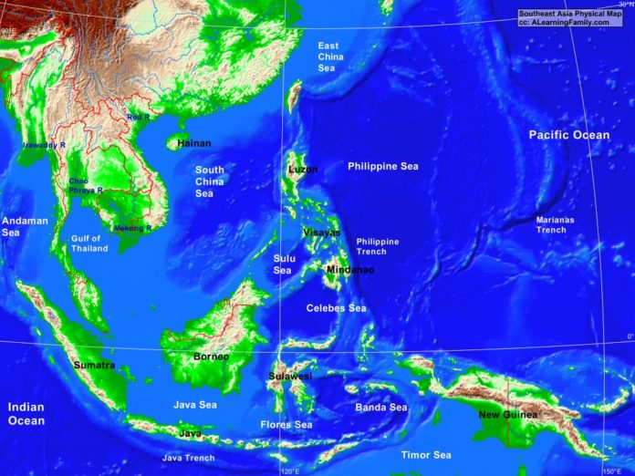
Southeast Asia physical map
A physical map of Southeast Asia (Creative Commons: A Learning Family).

The Southeast Asia physical map is provided. The physical map includes a list of major landforms and bodies of water of Southeast Asia.

A student may use the blank Southeast Asia outline map to practice locating these physical features.

Features of the Southeast Asia Physical Map

Bodies of Water

  • Andaman Sea
  • Banda Sea
  • Celebes Sea
  • East China Sea
  • Flores Sea
  • Gulf of Thailand
  • Indian Ocean
  • Java Sea
  • Pacific Ocean
  • Philippine Sea
  • South China Sea
  • Sulu Sea
  • Timor Sea

Major Landforms

  • Andaman Islands
  • Borneo
  • Chao Phraya River
  • Hainan
  • Irrawaddy River
  • Java
  • Java Trench
  • Luzon
  • Marianas Trench
  • Mekong River
  • Mindanao
  • New Guinea
  • Philippine Trench
  • Red River
  • Spratly Islands
  • Sulawesi
  • Sumatra
  • Visayas

Bibliography

Featured Posts