Sunday, May 19, 2024
Home Blog Page 44

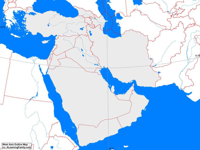
West Asia Outline Map

West Asia outline map
A blank outline map of West Asia (Creative Commons: A Learning Family).

The West Asia outline map is provided. The outline map includes a list of neighboring countries, capital cities, major landforms and bodies of water of West Asia.

A student may use the blank map to practice locating these political and physical features.

Features of the West Asia Outline Map

Neighboring Countries

  • Afghanistan
  • Bulgaria
  • Egypt
  • Greece
  • Pakistan
  • Russia
  • Turkmenistan

Countries and Capital Cities

  • Armenia (Yerevan)
  • Azerbaijan (Baku)
  • Bahrain (Manama)
  • Cyprus (Nicosia)
  • Georgia (Tbilisi)
  • Iraq (Baghdad)
  • Iran (Tehran)
  • Israel (Jerusalem)
  • Jordan (Amman)
  • Kuwait (Kuwait City)
  • Lebanon (Beirut)
  • Oman (Muscat)
  • Qatar (Doha)
  • Syria (Damascus)
  • Turkey (Ankara)
  • United Arab Emirates (Abu Dhabi)
  • Yemen (Sana’a)

Bodies of Water

  • Arabian Sea
  • Black Sea
  • Caspian Sea
  • Gulf of Aden
  • Gulf of Aqaba
  • Gulf of Oman
  • Gulf of Suez
  • Mediterranean Sea
  • Persian Gulf
  • Red Sea

Major Landforms

  • Anatolian Plateau
  • Ar Rub Al Khali
  • Arabian Peninsula
  • Asir Mountains
  • Caucasus Mountains
  • Elburz Mountains
  • Euphrates River
  • Hojaz Mountains
  • Iranian Plateau
  • Lut Desert
  • Salt Desert
  • Syrian Desert
  • Taurus Mountains
  • Tigris River
  • Zagros Mountains

Bibliography

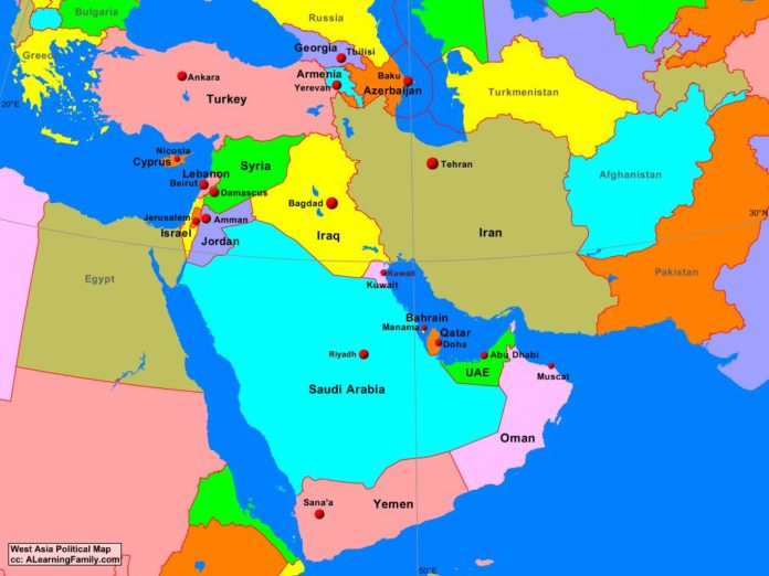
West Asia Political Map

West Asia political map
A political map of West Asia (Creative Commons: A Learning Family).

The West Asia political map is provided. The political map includes a list of neighboring countries and capital cities of West Asia.

A student may use the blank West Asia outline map to practice locating these political features.

Features of the West Asia Political Map

Neighboring Countries

  • Afghanistan
  • Bulgaria
  • Egypt
  • Greece
  • Pakistan
  • Russia
  • Turkmenistan

Countries and Capital Cities

  • Armenia (Yerevan)
  • Azerbaijan (Baku)
  • Bahrain (Manama)
  • Cyprus (Nicosia)
  • Georgia (Tbilisi)
  • Iraq (Baghdad)
  • Iran (Tehran)
  • Israel (Jerusalem)
  • Jordan (Amman)
  • Kuwait (Kuwait City)
  • Lebanon (Beirut)
  • Oman (Muscat)
  • Qatar (Doha)
  • Syria (Damascus)
  • Turkey (Ankara)
  • United Arab Emirates (Abu Dhabi)
  • Yemen (Sana’a)

Bibliography

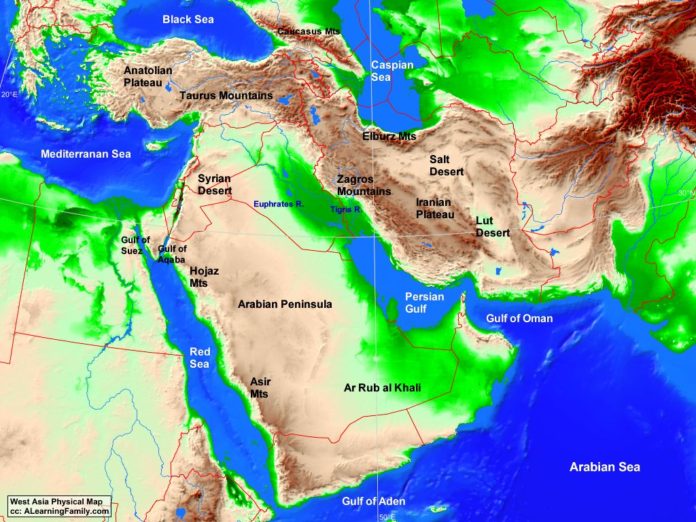
West Asia Physical Map

West Asia physical map
A physical map of West Asia (Creative Commons: A Learning Family).

The West Asia physical map is provided. The physical map includes a list of majo landforms and bodies of water of West Asia.

A student may use the blank West Asia outline map to practice locating these physical features.

Features of the West Asia Physical Map

Bodies of Water

  • Arabian Sea
  • Black Sea
  • Caspian Sea
  • Gulf of Aden
  • Gulf of Aqaba
  • Gulf of Oman
  • Gulf of Suez
  • Mediterranean Sea
  • Persian Gulf
  • Red Sea

Major Landforms

  • Anatolian Plateau
  • Ar Rub Al Khali
  • Arabian Peninsula
  • Asir Mountains
  • Caucasus Mountains
  • Elburz Mountains
  • Euphrates River
  • Hojaz Mountains
  • Iranian Plateau
  • Lut Desert
  • Salt Desert
  • Syrian Desert
  • Taurus Mountains
  • Tigris River
  • Zagros Mountains

Bibliography

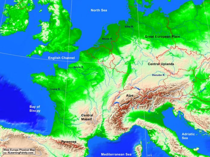
West Europe Physical Map

West Europe physical map
A physical map of West Europe (Creative Commons: A Learning Family).

The West Europe physical map is provided. The physical map includes a list of major landforms and bodies of water of West Europe.

A student may use the blank West Europe outline map to practice locating these physical features.

Features of the West Europe Physical Map

  • Croatia
  • Czech Republic
  • Denmark
  • Hungary
  • Ireland
  • Italy
  • Poland
  • Slovakia
  • Spain
  • United Kingdom

Countries and Capital Cities

  • Austria (Vienna)
  • Belgium (Brussels)
  • France (Paris)
  • Germany (Berlin)
  • Luxembourg (Luxembourg)
  • Netherlands (Amsterdam)
  • Switzerland (Bern)

Bodies of Water

  • Adriatic Sea
  • Bay of Biscay
  • English Channel
  • Mediterranean Sea
  • North Sea

Major Landforms

  • Alps
  • Central Massif
  • Central Uplands
  • Danube River
  • Elba River
  • Great European Plain
  • Loire River
  • Pyrennes Mountains
  • Rhine River
  • Seine River

Bibliography

Official Website of the European Union

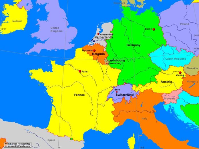
West Europe Political Map

West Europe political map
A political map of West Europe (Creative Commons: A Learning Family).

The West Europe political is provided. The political map includes a list of neighboring countries and major cities of West Europe.

A student may use the blank West Europe outline to practice locating these political features.

Features of the West Europe Political Map

Neighboring Countries

  • Croatia
  • Czech Republic
  • Denmark
  • Hungary
  • Ireland
  • Italy
  • Poland
  • Slovakia
  • Spain
  • United Kingdom

Countries and Capital Cities

  • Austria (Vienna)
  • Belgium (Brussels)
  • France (Paris)
  • Germany (Berlin)
  • Luxembourg (Luxembourg)
  • Netherlands (Amsterdam)
  • Switzerland (Bern)

Bibliography

Official Website of the European Union

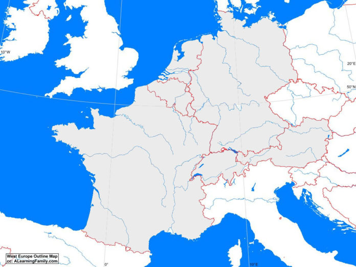
West Europe Outline Map

West Europe outline map
A blank outline map of West Europe (Creative Commons: A Learning Family).

The West Europe outline map is provided. The outline map includes a list of neighboring countries, major cities, major landforms and bodies of water of West Europe.

A student may use the blank map to practice locating these political and physical features.

Features of the West Europe Outline Map

Neighboring Countries

  • Croatia
  • Czech Republic
  • Denmark
  • Hungary
  • Ireland
  • Italy
  • Poland
  • Slovakia
  • Spain
  • United Kingdom

Countries and Capital Cities

  • Austria (Vienna)
  • Belgium (Brussels)
  • France (Paris)
  • Germany (Berlin)
  • Luxembourg (Luxembourg)
  • Netherlands (Amsterdam)
  • Switzerland (Bern)

Bodies of Water

  • Adriatic Sea
  • Bay of Biscay
  • English Channel
  • Mediterranean Sea
  • North Sea

Major Landforms

  • Alps
  • Central Massif
  • Central Uplands
  • Danube River
  • Elba River
  • Great European Plain
  • Loire River
  • Pyrennes Mountains
  • Rhine River
  • Seine River

Bibliography

Official Website of the European Union

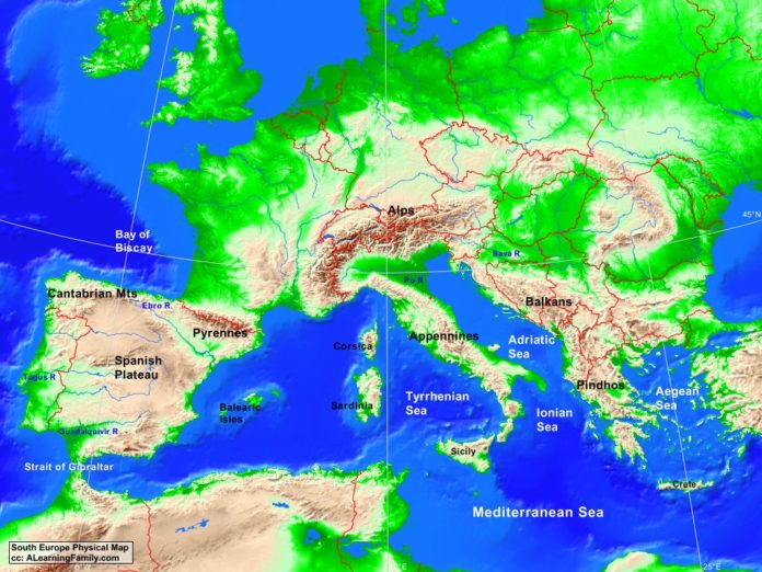
South Europe Physical Map

South Europe physical map
A physical map of South Europe (Creative Commons: A Learning Family).

The South Europe physical map is provided. The physical map includes a list of major landforms and bodies of water of South Europe.

A student may use the blank South Europe outline map to practice locating these physical features.

Features of the South Europe Physical Map

Bodies of Water

  • Adriatic Sea
  • Aegean Sea
  • Bay of Biscay
  • Ionic Sea
  • Mediterranean Sea
  • Strait of Gibraltar
  • Tyrrhenean Sea

Major Landforms

  • Alps Mountains
  • Appennines Mountains
  • Balearic Islands
  • Balkans Mountains
  • Cantabrian Mountains
  • Corsica
  • Crete
  • Ebro River
  • Guadalquivir River
  • Pindhos Mountains
  • Po River
  • Pyrennes Mountains
  • Sardinia
  • Sava River
  • Sicily
  • Spanish Plateau
  • Tagus River

Bibliography

Official Website of the European Union

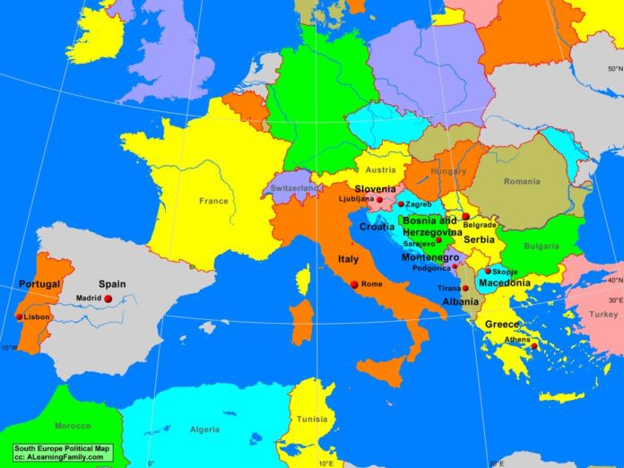
South Europe Political Map

South Europe politcal map
A political map of South Europe (Creative Commons: A Learning Family).

The South Europe political map is provided. The political map includes a list of neighboring countries and capital cities of South Europe.

A student may use the blank map to practice locating these political and physical features.

Features of the South Europe Outline Map

Neighboring Countries

  • Algeria
  • Austria
  • Bulgaria
  • France
  • Hungary
  • Morocco
  • Romania
  • Switzerland
  • Tunisia
  • Turkey

Countries and Capital Cities

  • Albania (Tirana)
  • Bosnia and Herzegovina (Sarajevo)
  • Croatia (Zagreb)
  • Greece (Athens)
  • Italy (Rome)
  • Macedonia (Skopje)
  • Portugal (Lisbon)
  • Serbia (Podgorica)
  • Slovenia (Ljubljana)
  • Spain (Madrid)

Bibliography

Official Website of the European Union

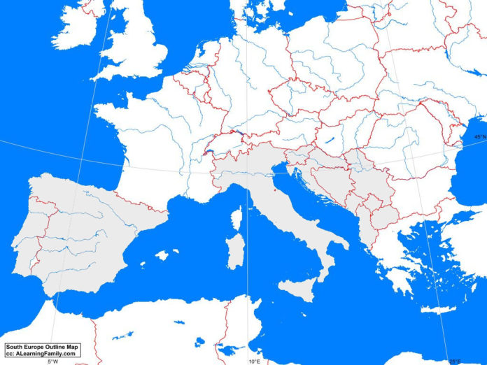
South Europe Outline Map

South Europe outline map
A blank outline map of South Europe (Creative Commons: A Learning Family).

The South Europe outline map is provided. The outline map includes a list of neighboring countries, capital cities, major landforms and bodies of water of South Europe.

A student may use the blank map to practice locating these political and physical features.

Features of the South Europe Outline Map

Neighboring Countries

  • Algeria
  • Austria
  • Bulgaria
  • France
  • Hungary
  • Morocco
  • Romania
  • Switzerland
  • Tunisia
  • Turkey

Countries and Capital Cities

  • Albania (Tirana)
  • Bosnia and Herzegovina (Sarajevo)
  • Croatia (Zagreb)
  • Greece (Athens)
  • Italy (Rome)
  • Macedonia (Skopje)
  • Portugal (Lisbon)
  • Serbia (Podgorica)
  • Slovenia (Ljubljana)
  • Spain (Madrid)

Bodies of Water

  • Adriatic Sea
  • Aegean Sea
  • Bay of Biscay
  • Ionic Sea
  • Mediterranean Sea
  • Strait of Gibraltar
  • Tyrrhenean Sea

Major Landforms

  • Alps Mountains
  • Appennines Mountains
  • Balearic Islands
  • Balkans Mountains
  • Cantabrian Mountains
  • Corsica
  • Crete
  • Ebro River
  • Guadalquivir River
  • Pindhos Mountains
  • Po River
  • Pyrennes Mountains
  • Sardinia
  • Sava River
  • Sicily
  • Spanish Plateau
  • Tagus River

Bibliography

Official Website of the European Union

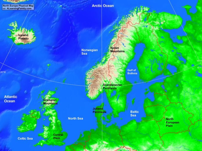
North Europe Physical Map

North Europe physical map
A physical map of North Europe (Creative Commons: A Learning Family).

The North Europe physical map is provided. The physical map includes a list of major landforms and bodies of water of North Europe.

A student may use the blank North Europe outline map to practice locating these physical features.

Features of the North Europe Physical Map

Bodies of Water

  • Arctic Ocean
  • Atlantic Ocean
  • Baltic Sea
  • Celtic Sea
  • Gulf of Bothnia
  • North Sea
  • Norwegian Sea

Major Landforms

  • Central Plain
  • Grampian Mountains
  • Iceland Plateau
  • Jutland Peninsula
  • Kjolen Mountains
  • North European Plain
  • Scandinavian Peninsula

Bibliography

Official Website of the European Union

Featured Posts